• Skip to primary navigation
  • Skip to main content
  • Skip to footer
Site logo

Continental Divide Trail Coalition

  • ×
  • My Cart
  • Donate
  • Explore The Trail
    • Interactive Map
    • Closures and Notices
      • CDT Incident Report Form
    • Day and Section Hiking Resources
      • Hike Suggestions
      • CDTC Guides
    • Thruhiking Resources
      • CDT Planning guide
      • Southern Terminus Shuttle
      • Maps & Data
      • Water Report (External Link)
      • CDTC Official List of CDT Thru-Hikers
    • Equestrian Resources
    • Hike Suggestions
    • Maps & Data
    • History of the CDT
    • The CDT Experience
  • Our Work
    • Trail Protection
      • Trail Management Policies
      • Conservation
    • Outreach and Education
    • Community Engagement
  • Get Involved
    • Volunteer
      • Volunteer FAQ
    • Adopt a Trail Program
    • Community Ambassadors
    • Advocacy Alerts & Policy
    • Land Manager Information
  • Gateway Communities
    • Colorado
      • Grand Lake
      • Pagosa Springs
      • Lake City
      • Leadville / Twin Lakes
      • Salida
      • South Fork
      • Steamboat Springs
    • Idaho / Montana
      • Anaconda
      • Butte
      • Helena
      • Lemhi County
      • Lincoln
    • New Mexico
      • Chama
      • Cuba
      • Grants
      • Silver City
    • Wyoming
      • Encampment / Riverside
      • Lander / South Pass City
      • Pinedale
      • Rawlins
    • Other Communities
  • News & Events
    • News
    • Events
      • Pride on the Divide – 2nd Annual
      • All Events
    • Publications
  • Donate
    • Legacy / Wills
    • CDT Endowment
    • Memorial Gifts
    • Business Memberships
  • Store
  • About Us
    • Contact Us
      • CDT Incident Report Form
    • Staff and Board
    • Employment
    • Corporate and Business Partners
    • Organizational Governance
    • Media Kit
  • My Cart
  • Donate
Mountain Range

Centennial Mountains and Blair Lake

  • Difficulty: Difficult

  • Length: 14 miles

  • Closest Town: West Yellowstone, MT

  • Directions: Directions from West Yellowstone, MT: Follow US-20 for 12 miles west to the junction with MT-87. Travel northwest on MT-87 for 5 miles and turn south at the Sawtell historical marker/Forest Service Rd 55/Henry’s Lake Rd. Follow the paved road around the west shore of Henry’s Lake, turning left onto FS Road 53 and then immediately right onto Red Rock Pass Road/FS Rd 58 (an improved dirt road). Follow Red Rock Pass Road for approximately 5 miles to signs marking Red Rock Pass at the Montana-Idaho border. The trailhead and the trail will be on your left but dispersed camping and parking is available on both sides of the road (44.598418, -111.520566). For equestrian users, note that parking may be difficult for a horse trailer.

  • Maps:

    USGS 7.5 quadrangles: Mount Jefferson, Upper Red Rock Lake, and Slide Mountain; USFS: Targee National Forest, Island Park/Ashton. CDTC Map Set: Maps 301 and 302, Sections MT02 and MT03.

  • For More Information:

    Bureau of Land Management Dillon Field Office: (406)- 683-2337. Targhee National Forest, Dubois Ranger District: (208)-374-5422.

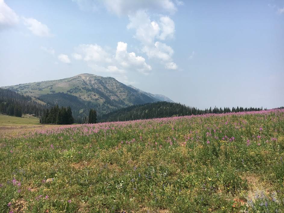
Enjoy spectacular views from the Continental Divide to the Island Park Caldera along the Montana-Idaho border, follow Hell Roaring Creek, where anglers can cast for trout on their way to Blair Lake, and visit the Red Rock Lakes National Wildlife Refuge, declared by many to be the most beautiful national wildlife refuge in the country. The rugged Centennial Mountains, rising more than 9,000 feet above the Centennial Valley wetlands, provide a dramatic backdrop for this extremely remote refuge. The best time to hike is July through September when snow is melted and the creeks are passable. If you want to spend time at the refuge, there is a shorter hike option. Instead of going to Blair Lake, follow signs to Lillian Lake, cross Hell Roaring Creek, and climb into beautiful open meadows and forested groves. Cross Hell Roaring Creek a second time before Lillian Lake appears above you as you climb a little higher.

Photo by Matt Berger

Ferns

Help Support the Continental Divide Trail Coalition

Donate Today!
Camping backpack

Visit our store!

Proceeds from all products sold through the CDTC Trail Shop support our work to complete, promote, and protect the Continental Divide Trail, so you can rep the CDT with pride knowing your dollars support the trail you love.

Visit our Trail Shop
Creek

Newsletter Sign Up

Sign up here to make sure you hear about CDTC news and events! You’ll receive our monthly e-news and other occasional trail updates.

Email me about CDT events in...

Footer

Continental Divide Trail Coalition

CDTC is a 501(c)(3) charitable organization

  • 710 10th Street, Suite 200
  • Golden, CO 80401
  • Tel: (303)996-2759
  • Homepage
  • Explore The Trail
  • Gateway Communities
  • About Us
  • Employment
  • What We Do
  • News & Events
  • Volunteer
  • Store
  • Donate
  • My Cart
  • Donate

Corporate Partners

Learn more
YETI
ULA logo in white

Commitment to Transparency


CDTC is a platinum-level GuideStar participant, demonstrating our commitment to transparency.

© 2023 Continental Divide Trail Coalition · Privacy Policy · Terms of Service · Website Designed & Developed by ThompsonStenning