• Skip to primary navigation
  • Skip to main content
  • Skip to footer
Site logo

Continental Divide Trail Coalition

  • ×
  • My Cart
  • Donate
  • Explore The Trail
    • Interactive Map
    • Closures and Notices
    • Day and Section Hiking Resources
      • Hike Suggestions
      • CDTC Guides
    • Thruhiking Resources
      • CDT Planning guide
      • Southern Terminus Shuttle
      • Maps & Data
      • Water Report (External Link)
      • CDTC Official List of CDT Thru-Hikers
    • Equestrian Resources
    • Hike Suggestions
    • Maps & Data
    • History of the CDT
    • The CDT Experience
  • Our Work
    • Trail Protection
      • Trail Management Policies
      • Conservation
    • Outreach and Education
    • Community Engagement
  • Get Involved
    • Volunteer
      • Volunteer FAQ
    • Adopt a Trail Program
    • Community Ambassadors
    • Advocacy Alerts & Policy
    • Land Manager Information
  • Gateway Communities
    • Colorado
      • Grand Lake
      • Pagosa Springs
      • Lake City
      • Leadville / Twin Lakes
      • Salida
      • South Fork
      • Steamboat Springs
    • Idaho / Montana
      • Anaconda
      • Butte
      • Helena
      • Lemhi County
      • Lincoln
    • New Mexico
      • Chama
      • Cuba
      • Grants
      • Silver City
    • Wyoming
      • Encampment / Riverside
      • Lander / South Pass City
      • Pinedale
      • Rawlins
    • Other Communities
  • News & Events
    • News
    • Events
      • Pride on the Divide – 2nd Annual
      • All Events
    • Publications
  • Donate
    • Legacy / Wills
    • CDT Endowment
    • Memorial Gifts
    • Business Memberships
  • Store
  • About Us
    • Contact Us
    • Staff and Board
    • Employment
    • Corporate and Business Partners
    • Organizational Governance
    • Media Kit
  • My Cart
  • Donate
Mountain Range

Rocky Mountain National Park

  • Difficulty: Moderate

  • Length: 28-mile loop.

  • Directions: Grand Lake/East Shore Trailhead: From US-34 drive east into Grand Lake 0.2 mile and take a right onto Center Drive. Drive another 0.2 mile to Marina Drive, turn left, and go one block to Shadow Mountain Drive. Turn right and proceed 0.3 mile to Jericho Avenue, turn right across the bridge and drive .5 mile to the stop sign at Shoreline Landing. Turn left and you will see the parking area at the dead end road. North Inlet Trailhead: Drive into the Town of Grand Lake on Grand Avenue. The trailhead is less than .5 mile north of town at the filtration plant. Knight Ridge Trail: Take Highway 34 north from Granby to the entrance of the Arapaho National Recreation Area. Travel east on Forest Road 125 for about 10 miles to the Arapaho Bay Campground. Turn left and go about a half mile to the trailhead on the right. The Knight Ridge trail begins from the Roaring Fork Trailhead and shortly splits from the Roaring Fork Trail and travels through the campground

  • Maps:

    USGS 7.5 Quadrangles: Mount Richthofen, Bowen Mountain, Grand Lake, Shadow Mountain

  • For More Information:

    Rocky Mountain National Park: http://www.nps.gov/romo/

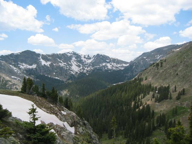
One-third of Rocky Mountain National Park is above tree line, rising above verdant valleys, twisting rivers, and glistening lakes. Twenty-eight miles of the Continental Divide Trail passes through the park giving hikers a chance to glimpse at these incredible high altitude views through the montane and sub-alpine life systems at elevations of 8,000 to 11,500 feet. West of the Divide, lodgepole pines dominate the lower elevations while aromatic Douglas and subalpine firs as well as Englemann spruce adorn higher points. Follow the Green Mountain Trail, which overlaps the CDT, east to the Tonahutu Trail; continue east to the junction with the North Inlet Trail while gaining over 2,000 feet of elevation. Where these two trails meet about 12 miles into the trip the route touches the divide at 12,324 feet with beautiful, unspoiled views west of the Divide. Follow the North Inlet Trail southwest toward Grand Lake until reaching the Tonahutu/North Inlet Parking Area. Designated campsites are prevalent along the trails and permits may be purchased at the Kawuneeche Visitor Center. Contact: CDTC at 1-720-340-CDTC (2382) or Rocky Mountain National Park 970-627-3471 or the RMNP Backcountry Office 970-586-2371.

Family Friendly Option

RMNP access:For a short hike in RMNP, access the Tonahutu/North Inlet Trailhead RMNP/Arapaho National Forest access:Further south from the Park, you will find a recreation haven along the shores of Shadow Mountain Lake down to Lake Granby. There are nearly 14 miles of trail south of Grand Lake that travel along the two large bodies of water. Access points are from the Shadow Mtn Dam as well as the East Shore and Knight Ridge Trails.

Ferns

Help Support the Continental Divide Trail Coalition

Donate Today!
Camping backpack

Visit our store!

Proceeds from all products sold through the CDTC Trail Shop support our work to complete, promote, and protect the Continental Divide Trail, so you can rep the CDT with pride knowing your dollars support the trail you love.

Visit our Trail Shop
Creek

Newsletter Sign Up

Sign up here to make sure you hear about CDTC news and events! You’ll receive our monthly e-news and other occasional trail updates.

Email me about CDT events in...

Footer

Continental Divide Trail Coalition

CDTC is a 501(c)(3) charitable organization

  • 710 10th Street, Suite 200
  • Golden, CO 80401
  • Tel: (303)996-2759
  • Homepage
  • Explore The Trail
  • Gateway Communities
  • About Us
  • Employment
  • What We Do
  • News & Events
  • Volunteer
  • Store
  • Donate
  • My Cart
  • Donate

Corporate Partners

Learn more
YETI
ULA logo in white

Commitment to Transparency


CDTC is a platinum-level GuideStar participant, demonstrating our commitment to transparency.

© 2023 Continental Divide Trail Coalition · Privacy Policy · Terms of Service · Website Designed & Developed by ThompsonStenning