Guest blog by Eloise “Fun size” Robbins
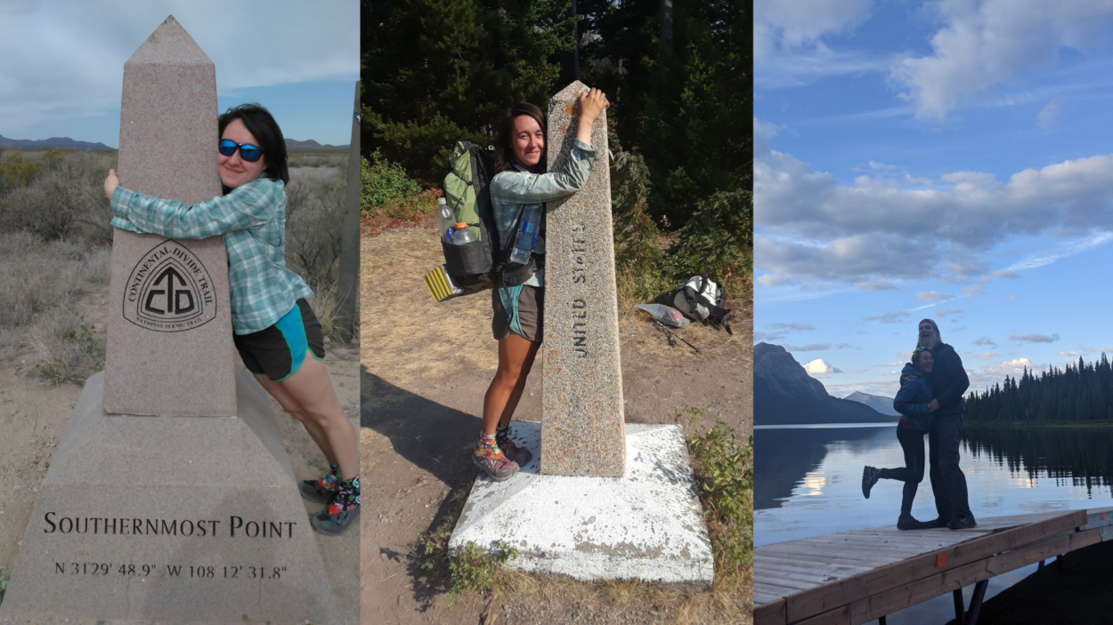
The Continental Divide watershed spans both North and South America, from Patagonia to Alaska. The Continental Divide National Scenic Trail (CDT) covers 3,100 of these miles (4989 km), from the Mexico-New Mexico border to the Montana-Canada border in Glacier National Park. The Great Divide Trail (GDT) continues from the CDT terminus in Waterton Lakes National Park and follows the divide for another 1095 km (680 miles) along the Alberta-British Columbia border to Kakwa Provincial Park. The trail ends there, but the divide continues, crossing the BC-Yukon Border, and then back into the US, running for thousands of kilometers to finish at the ocean at Cape Prince of Wales in Alaska.
Many trails crisscross the divide on the long journey between Alaska and Patagonia. The CDT and the GDT are two of the longest and most renowned. On paper, they are two entirely different trails: different trail organizations support them, different land managers govern the surrounding areas, and they cross through entirely different countries. However, it’s hard to distinguish them when you stand at the end of the CDT at the US-Canada border and the trail continues north, uninterrupted.
Similarities
The CDT and GDT can be very different trails, traversing different countries and ecosystems; however, they have a lot of shared traits.
Scenery
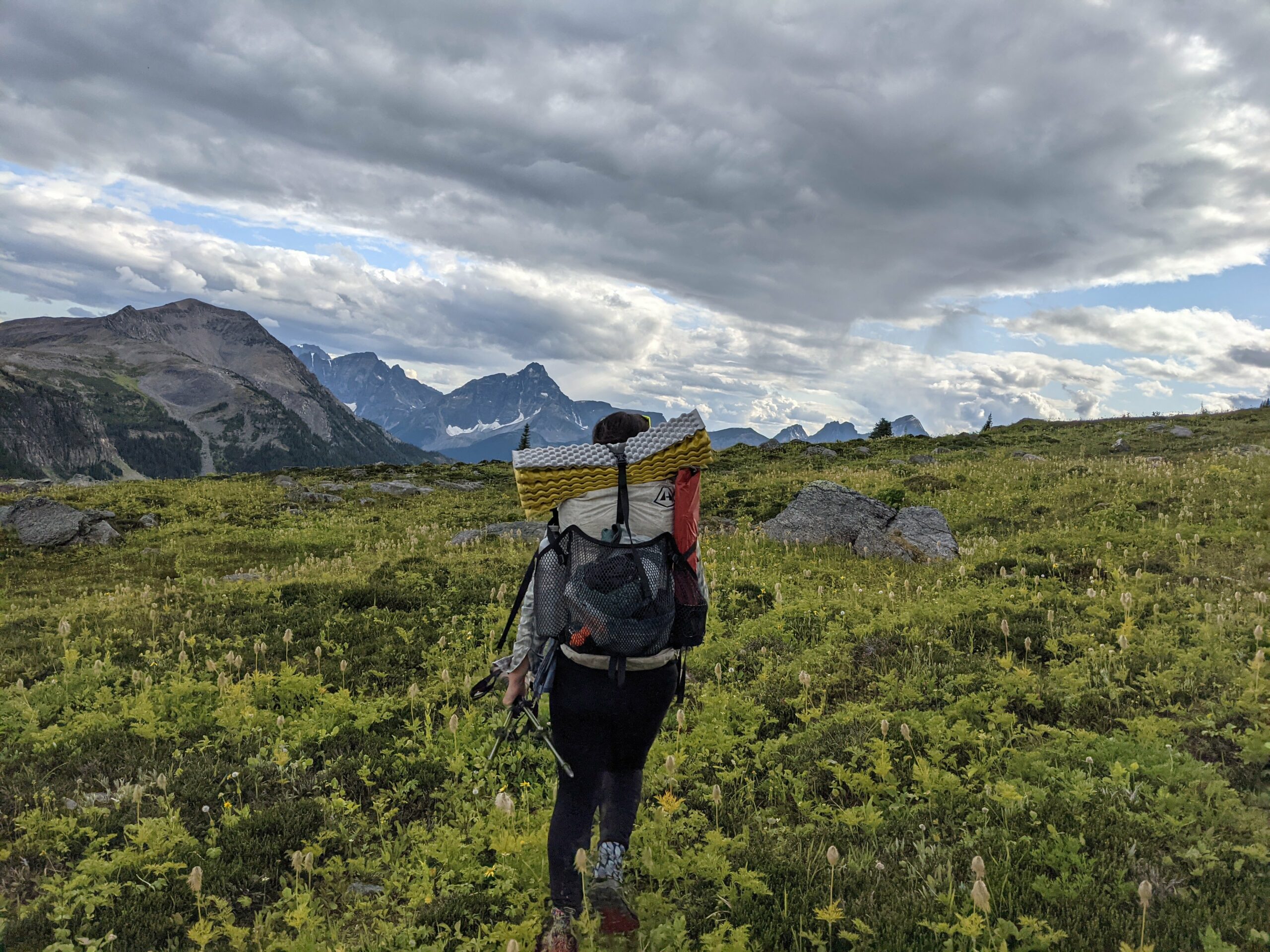
The GDT and CDT share a lot in common: part trail and part route, challenging terrain, ass-kicking weather, abundant wildlife and beautiful scenery. The biggest difference is that all of these things are exponentially higher on the GDT. The scenery in particular is non-stop awe inspiring, in-your-face kind of gorgeous. Leslie “Tour Guide” Gerein (GDT 2016, CDT 2017)
Both trails boast world-class scenery. The highlights on the CDT include the desert, the San Juans, the Wind River Range, Yellowstone, and Glacier National parks. These are some of the prettiest places to hike in the entire US. The GDT keeps the jaw-dropping scenery going, with breathtaking views every single day.
Challenge
The CDT is commonly referred to as the most challenging of the triple crown trails (Appalachian Trail, Pacific Crest Trail, and the CDT). Remote, wild, and with a full list of hazards that we’ll explore in our next paragraph, the CDT’s unofficial tag-line is “embrace the brutality.” The GDT kicks the difficulty up a notch, with even more wild, remote, and sometimes trail-less routes. Neither trail is easy to hike, but the GDT can feel more like a survival experience than a thru-hike, especially in the northern sections.
Hazards
The CDT and the GDT share several hazards to keep hikers on their toes.
Weather: Thunderstorms characterize summer on the US divide, with Colorado being particularly well-known for afternoon lightning. Hikers will also face hail and lightning on the Canadian divide, although storms often lack the frequency and intensity of the CDT. Hikers on the GDT are more likely to encounter at least one summer snowstorm, especially further north on the trail. Falling snow isn’t uncommon on the CDT, especially in early or late season, but it’s almost a certainty on the GDT.
Wildlife: Bears are the biggest concern north of the Wind River Range, with most hikers choosing to carry bear spray for grizzly defense. Bears are even more common north of the border, and most thru-hikers on the GDT will see at least one grizzly. Hikers may also encounter mountain lions, moose, elk, lynx, and maybe even a wolf if they are very lucky.
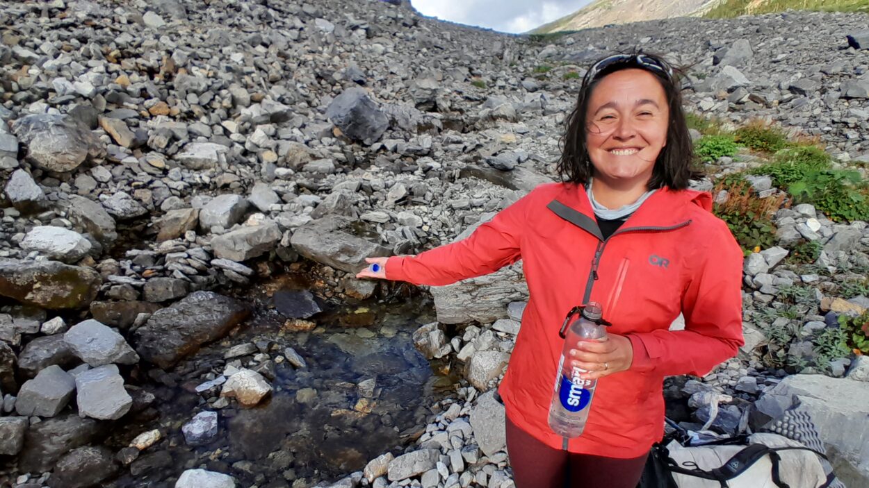
Water: River crossings on both the CDT and the GDT can challenge hikers. Many crossings on both trails are still unbridged, and glacial-fed streams and snow melt can pose a problem. Hikers on both trails should attempt to cross in the morning when water is lower, or be prepared to turn around if the river is too high.
Differences
Ecosystems
Regardless of the border, the Divide offers expansive mountain scenery and unpredictable weather on challenging, rugged trail. The GDT grants access to unparalleled remote wilderness at the price of greater navigational demands and more red tape; by virtue of its scale, the CDT provides more diverse landscapes and an established thru-hiking culture. Nicole “Trash Panda” Dubeta (GDT 2021, CDT 2023)
The CDT traverses diverse ecosystems as it hugs the divide. Northbound hikers start in the New Mexico desert, where water is scarce and spikey desert plants are more common than trees. There’s nothing like the magical New Mexico desert anywhere on the GDT. The trail climbs into the pine forests of Northern New Mexico, before cresting high-altitude alpine in Colorado. Wyoming’s Great Divide Basin feels like a return to the desert, as water becomes scarce again, and pronghorn antelope run over rolling hills. The trail comes back to snowy peaks in the Wind River Range, and continues over more mountainous terrain to Glacier National Park (with a few breaks for rolling grassland, and the exciting thermal landscape of Yellowstone National Park.) Watching the landscape and ecosystems change is one of the most rewarding parts of a CDT thru-hike.
By comparison, changes along the GDT are much more subtle. The trail follows the steep rock walls that constitute the divide in Canada, before scrambling over high passes. Hikers will need a keen eye to spot differences in terrain between Waterton and Jasper. North of Jasper, the weather is a larger indicator than geography that hikers are now crossing an inland rainforest. The GDT does not have the ecological change that characterizes a thru-hike on the CDT, but the landscape is still stunning.
Hiking Season
If you include both the NoBo and SoBo hiking season along the entire CDT, hikers have between April and November when it is feasible to be on trail. The GDT is far more limited due to its northern location. Hikers in the Canadian Rockies only really have July, August, and maybe September to hike without significant snowfall (and a mid-summer snowstorm is almost a certainty for thru-hikers).
Permits/Planning
The CDT is an easy trail to plan. Hikers only need to worry about permits in a few national parks, which can mostly be obtained just a few days before hikers reach these areas. Reserving a spot on the CDTC’s Southern Terminus Shuttle and perhaps mailing a few boxes is about all NoBo thru-hikers have to worry about. Once on the trail, it’s easy to enjoy freedom with no set itinerary and no reservations.
The GDT isn’t so simple. Planning a GDT thru-hike can be more challenging than hiking the trail. The GDT crosses through five national parks, and campsites in each park must be reserved individually for specific dates. While this is necessary to protect the most scenic and popular areas along the entire continental divide, it is a headache for thru-hikers. Prospective hikers should start planning their trips in January, when reservations normally open. Popular sites along the Rockwall and Skyline trails book in minutes. Sections B, D, F and G can be completed with minimal or easy-to-get permits for hikers who missed the reservation window. Hikers will also want to mail resupply boxes, since many of the resupply towns along the GDT are smaller and more expensive than the CDT options.
Difficulty
The GDT is the natural progression for a NoBo CDT hike. The southern portions increasingly challenge you physically, mentally, navigationally, and logistically. GDT sections F+G are a final exam, testing you on all that you’ve learned. Tania “Shamrock” Roenitz and Oliver “Scraps” Roenitz (GDT 2021, CDT 2023)
The CDT is not an easy trail. High elevation, wild weather and animal encounters conspire to challenge even experienced hikers. And while on paper, the GDT may not appear more difficult (it is shorter, after all), hikers should not underestimate just how much harder the Canadian divide can be. It can be easy to cover large daily distances on the CDT: the trail gets high, stays high, and features the least elevation gain and loss of the three US triple crown trails. The GDT, on the other hand, can be painfully slow. Bushwhacking, tricky navigation, lack of trail, and steep climbs all conspire to bog hikers down. Add in weather, tricky river crossings, and animals, and the GDT should not be underestimated.
Conclusion
“The Continental Divide Trail Coalition is committed to being a convenor of the communities that live, work, and love the Continental Divide landscape. It’s a shared devotion to the protection of this land that brings us together. Working with organizations like the Great Divide Trail Association amplifies awareness of these iconic spaces as vital pathways, ecological reservoirs, and places of deep cultural connection—and that the Continental Divide doesn’t stop at the U.S.-Canada border. We might be two trails, but we are united on the Divide,” CDTC Executive Director (she/her/ella) Teresa Martinez.
“In this untamed expanse shared by the Great Divide Trail and the Continental Divide Trail, there are no boundaries; we are interconnected at our most primal level. Similar to the Continental Divide Trail Coalition, the Great Divide Trail Association is dedicated to safeguarding not just the trail itself, but also the expansive wilderness that hosts diverse ecosystems, inhabitants, and historical significance. The necessity of collaborating to educate, conserve, and protect these natural attributes of the landscape is unquestionable.” GDTA Executive Director (she/her/elle) Kate Hamilton
While the CDT and GDT are separate trails, they are intrinsically linked by the divide. If you love and support the CDT, the GDT should be on your hiking bucket list. If you’re a GDT hiker, volunteer, or donor, the CDT should interest you. You can find out more about the GDT on the Great Divide Trail Association website.
Eloise “Fun Size” Robbins thru-hiked the CDT in 2017 and the GDT in 2021. She’s hiked a few other trails—including the PCT and AT— and plans to thru-hike the GDT again this year.


